[This landing page follows the DataCite Metadata Scheme (doi:10.5438/0010) to facilitate the generation of a standard compliant DOI entry.]
Identifier
doi:10.5676/DWD_EMIR/V001
identifierType
DOI
Creator
Bennartz, Ralf; Stengel, Martin; Schroeder, Marc; Hollmann, Rainer; Picard, Bruno; Fell, Frank
Title
Total column water vapour from the Microwave Radiometer (MWR) instruments
onboard ERS-1, ERS-2, and ENVISAT
Publisher
Deutscher Wetterdienst (DWD)
PublicationYear
2016
Subject
551 Geology, hydrology, meteorology
subjectScheme
Dewey Decimal Classification (DDC)
contributerType
Funder
contributerName
European Space Agency (ESA)
Date
1992-10-23/2012-04-08
dateType
Available
ResourceTyoe
Research Data
resourceTypeGeneral
Dataset
Size
Level-2 orbital data have a size of typically 2.0 MB and comprise 1 day of data. Level-3 monthy means encompass
the full time series and amount to 57.6 MB at 2° × 2° and 25.6 MB at 3° × 3° resolution.
Format
NetCDF CF-1.6
Version
EMiR Version 1
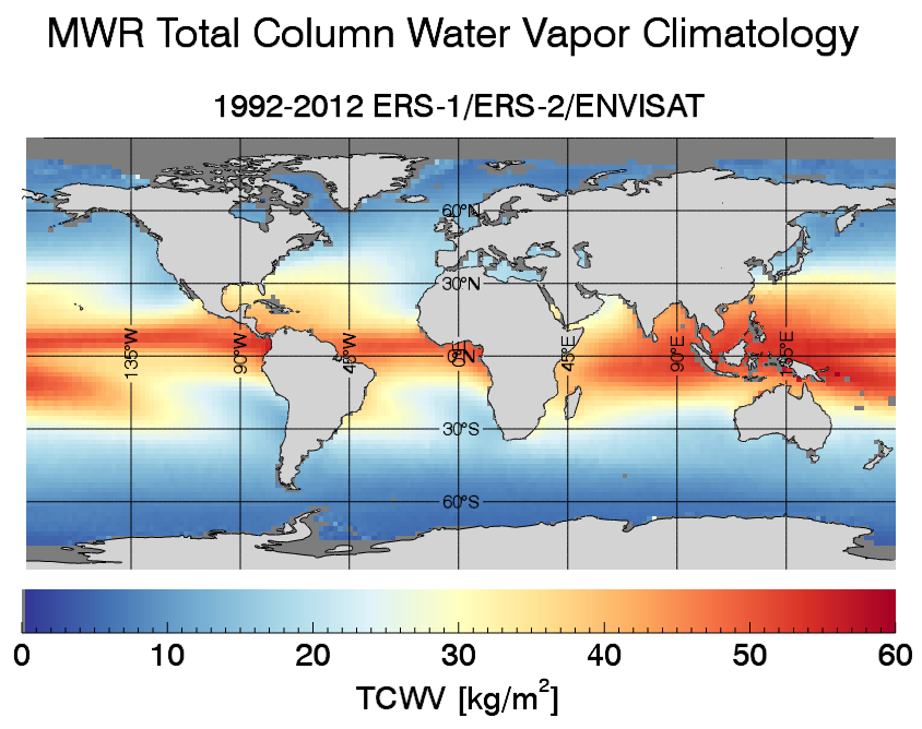
The Microwave Radiometer (MWR) flown on-board Envisat, ERS-1, and ERS-2 has provided a time series of global microwave observations over a period of nearly 21 years between 1991 and 2012. A successor instrument with very similar characteristics will be carried on-board the Sentinel-3 suite of satellites, which will extend the availability of the MWR observations from early 2016 well into the mid-2020s and possibly beyond.
Unlike methods relying on infrared or visible/near-infrared techniques, microwave observations allow for accurate retrievals of total column water vapour (TCWV) and liquid water path (LWP) also under cloudy conditions. In order to improve the quality and usefulness of MWR observations, the European Space Agency (ESA) has commissioned the project "ERS/Envisat MWR Recalibration and Water Vapour Thematic Data Record Generation" (EMiR) as part of their Long-Term Data Preservation (LTDP) activities. In this context, fully re- and inter-calibrated data records of MWR brightness temperatures and derived TCWV have been generated. In support of ocean altimetry, the wet tropospheric delay has been additionally calculated from the EMiR TCWV and ERA-Interim atmospheric fields.
The EMiR dataset is provided for individual orbits at MWR's native spatial resolution of typically 20 km (Level-2) as well in a gridded form for monthly mean values in spatial resolutions of 2° × 2° and 3° × 3° (Level 3). descriptionType
Abstract
geoLocationPlace
The EMiR dataset is available for the global ice-free ocean.
Known issues
- ERS-1 data between prior to 1992/10/23 have not been used for the generation of the EMiR dataset
since the altimeter time tag is not available for this period.
- There are a number of observation gaps in the EMiR dataset, the longest one between 1993/12/21 and 1994/04/09 (ERS-1).
- Closer than ca. 50 km to the coastline, the product quality is reduced due to land contamination.
- Product quality is also reduced in the presence of heavy precipitation.
Data access
- Level 2, swath-based data: https://public.satproj.klima.dwd.de/data/ESA_EMIR/EMIR_MWR_full_newset_v1.0/Level2/
- Level 3, monthly mean values at 2° × 2° and 3° × 3°: https://public.satproj.klima.dwd.de/data/ESA_EMIR/EMIR_MWR_full_newset_v1.0/Level3/
Disclaimer
The EMiR dataset was assembled as a service to the atmospheric and oceanic research community.
No warranties to the correctness and accuracy of the information therein can be made.
Cite this work
The EMiR dataset should be cited as follows: Bennartz, R., M. Stengel, M. Schröder, R. Hollmann, B. Picard,
and F. Fell (2016): Total column water vapour from the Microwave Radiometer (MWR) instruments
onboard ERS-1, ERS-2, and ENVISAT,
doi:10.5676/DWD_EMIR/V001.